EarthCam's Visual Information Ecosystem
EarthCam's Visual Information Ecosystem
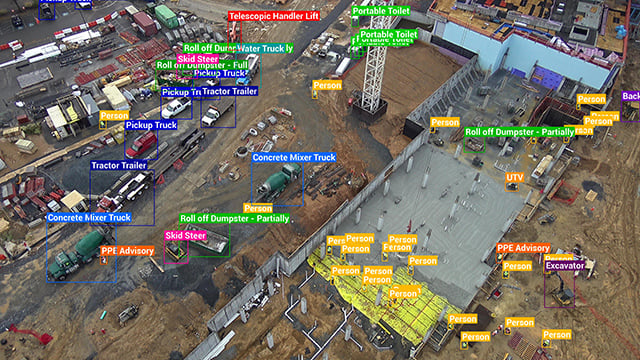
Using state-of-the-art, server-side AI and Edge Computer Vision, EarthCam has delivered numerous AI breakthroughs for site safety and productivity, detecting over 85 different types of equipment, construction materials, and their status, creating an almost infinite, searchable dataset of events and interactions. Automated alerts, tags and natural language search allow teams to act more quickly based on concise, targeted information.

 Comprehensive Visual Intelligence
The completely redesigned Control Center 9 AI Media Dashboard provides easy access and visibility into jobsite trends and insights from EarthCam’s advanced AI. Display real-time status updates, such as PPE advisories or notifications when workers are close to energized equipment. Easily find video of specific events or interactions with Natural Language Search.
 EarthCam Pano VI
EarthCam's Panoramic Visual Intelligence automatically creates a 360° visual audit of the entire jobsite with a single camera. Advanced AI algorithms generate accurate object counts, and provide a continuous, comprehensive overview of jobsite activity with panoramic images and metadata.
EarthCam Jobsite Health
 EarthCam Jobsite Health
Jobsite Health reports key data points derived from visual information generated hourly throughout the project, presenting them in a concise dashboard as Readiness, Activity and Stress, similar to a smartwatch report on individual biometrics.
 World’s First AI Material Analysis
Real-time cameras are combined with AI to identify, highlight and indicate the spatial configuration of materials within the environment. Materials are annotated, and work-in-place verification is automatically added to project management dashboards.
Alerts for Workers at Height
 Alerts for Workers at Height
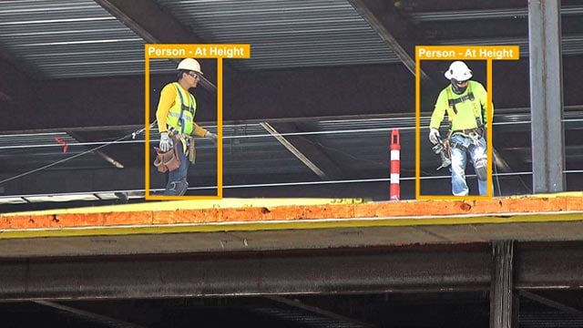
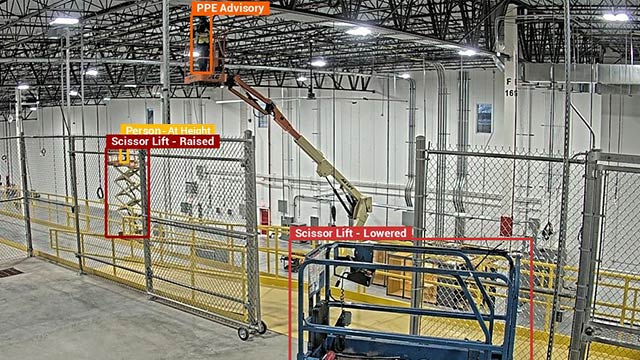
Identify the presence of ladders on the jobsite, and advise when workers are at height with significant accuracy using computer vision. Alerts are customized based on predefined actions such as when people climb a ladder, work on scaffolding or operate an elevated scissor lift.
AI Equipment & Vehicle Monitoring
 AI Equipment & Vehicle Monitoring
Ensure safer and more efficient equipment and vehicle operations. Detect unauthorized use, improper operation, and idle time, reducing maintenance and downtime. Real-time alerts provide managers with actionable insights for safety and compliance.
 Fast-Track Custom Analytics
Integrate with in-house or third-party systems easily, leveraging EarthCam’s in-house team of engineers & data scientists. Fast-track custom analytics for your unique use-cases, using the RESTful API, or easily implement EarthCam's 'off the shelf' package of powerful AI analytics.
Contact us to implement AI. We'll provide a free use-case analysis.
 Project Management Integration
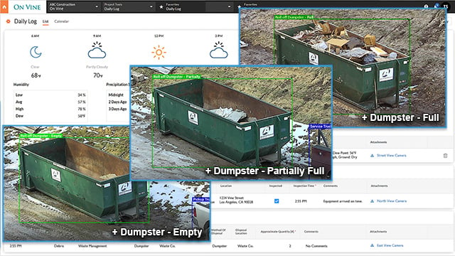
EarthCam's AI supercharges project management with automated visual data uploads to Procore Daily Logs, Autodesk Build and many other platforms. Share progress milestones, deliveries, safety and security. Learn more about our partner relationships.
See EarthCam's Partner Integrations.
AI-powered Time-lapse Production
 AI-powered Time-lapse Production
EarthCam's AI automatically removes under/overexposed sections and weather-compromised imagery. 16 different undesirable features, including dirt, fog or rain droplets are identified and excluded from your time-lapse video. Changes in site condition or camera installation defects which affect image capture quality are also detected.
 AI-Curated Virtual Tourism Streams
On EarthCam's network of webcams around the world, EarthCam AI works like a full-time automated content curator, orienting cameras for the most dramatic imagery, with the best exposure and angle of view. Twenty-four parameters are used including historical data, weather time, day, month, year, the position of the sun, even celestial events like sunrise, sunsets & moon position.


